


Oct 27th
This Hike of the Day starts from the Fourmile Creek Trailhead also know as South Foothills Trail off Lee Hill Road in North Boulder. Jann walks the trail towards the washed out area where it’s possible to walk and mountain bike but currently is not wheelchair accessible and continues by Old Kiln Trail and the Dog Park just off the path.

Oct 27th
This hike of the day starts from the 4th Street Bike Route and Wonderland Hill Bike Route crossing, where people run, bike, and walk on this multi-use path not to far from Bear Mountain.

Feb 18th
Everything you have wanted to know about high winds in Boulder, and then some.
In a nut shell: In 42 years worth of data, 175 days recorded winds of 70 m.p.h. or greater. Eighty six of these occurred in December and January. The highest wind gust recorded was 137 m.p.h. on Jan. 16-17, 1982, with 20 gusts of greater than 120 m. p. h. Forty percent of all Boulder buildings sustained damage. Most of the highest winds were in south Boulder.
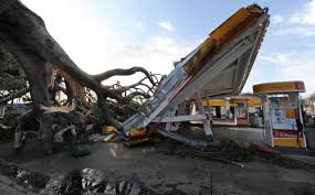
The highest wind recorded in the Boulder area was 137 mph
Boulder has some of the highest peak winds of any city in the US.
For data and tables, go to:
http://www.esrl.noaa.gov/psd/boulder/wind.html


