


May 1st
 City of Boulder’s Open Space and Mountain Parks (OSMP) Department will begin seasonal area closures to protect grassland ground-nesting birds beginning Thursday, May 1.
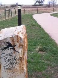
These closures will be in effect until July 31.
No designated trails will be closed as part of this protective measure.
The areas closed for grassland ground-nesting birds are:
Both sides of the Greenbelt Plateau Trail from Community Ditch Trail to the Greenbelt Plateau Trailhead on state Highway 128. Dogs will be allowed on the Greenbelt Plateau only if they are on leash (the trail is normally voice-and-sight control);
The area north of Community Ditch Trail and west of state Highway 93;
The area north of the Flatirons Vista North Trail and west of Highway 93 on top of the mesa;
The area north of the South Boulder Creek West Trail, east of the Bluestem Connector and south of Shanahan Ridge (dogs are prohibited in this area year-round).
Dog regulations on both the Community Ditch and Doudy Draw trails will remain voice-and-sight control.
For a variety of reasons, grassland bird populations in North America have declined sharply in the last several decades. Three species that OSMP monitors – Grasshopper Sparrows, Horned Larks and Lark Sparrows – have suffered at least a 50-percent population decline in the last 40 years, according to the National Audubon Society. The closures OSMP will implement Thursday are important in protecting these species’ habitats by keeping people and their pets away as the birds attempt to nest.
Please help OSMP protect these species and other ground-nesting birds by respecting the closures. Trespass violations can result in a summons with penalties up to 90 days in jail and/or a $1,000 fine.
Source: City of Boulder
Jun 27th
But this could back fire and drive fire fighters out of Shanahan ridge. Fire could destroy that entire area in the next three days. Below , weather report from NOAA does not bode well for Boulder. We are in a Red Flag warning high fire state. It would be prudent to pack your entire home if you live in Shanahan ridge area. You could lose it all.
THIS HAZARDOUS WEATHER OUTLOOK IS FOR NORTHEAST AND NORTH CENTRAL
COLORADO.
.DAY ONE…TODAY AND TONIGHT
INCREASING CLOUDS OVER COLORADO AT MIDDAY WILL SPAWN SCATTERED
THUNDERSTORMS IN THE MOUNTAINS AND OVER THE FRONT RANGE FOOTHILLS
THIS AFTERNOON. SOME OF THESE STORMS WILL PRODUCE STRONG AND GUSTY
WINDS AND FREQUENT CLOUD-TO-GROUND LIGHTNING. WHILE OTHER STORMS
MAY DEPOSIT UP TO A QUARTER INCH OF RAIN IN LESS THAN 30 MINUTES.
THUNDERSTORMS ARE THEN EXPECTED TO MOVE OUT OVER THE NEARBY PLAINS
WHERE THEY MAY PRODUCE SIMILAR WIND GUSTS AND DANGEROUS LIGHTNING.
HOWEVER…STORM COVERAGE IS NOT EXPECTED TO BE AS GREAT AS THAT IN
THE HIGH COUNTRY. MOST OF THIS STORM ACTIVITY SHOULD DIMINISH
LATER THIS EVENING.
OTHERWISE..SLIGHTLY COOLER TEMPERATURES AND HIGHER HUMIDITIES ARE
ON TAP FOR THE OUTLOOK AREA TODAY. A WEAK COLD FRONT BACKING INTO
NORTHEAST COLORADO EARLY THIS AFTERNOON WILL BE RESPONSIBLE FOR
SOME OF THE COOLING ON THE PLAINS.
This Afternoon: Scattered showers and thunderstorms, mainly after 3pm. Mostly cloudy, with a high near 94. Southwest wind 9 to 13 mph becoming east southeast. Winds could gust as high as 17 mph. Chance of precipitation is 40%.
Tonight: Isolated showers and thunderstorms before midnight. Mostly cloudy, with a low around 65. South southeast wind 6 to 14 mph becoming west northwest. Winds could gust as high as 20 mph. Chance of precipitation is 10%.
Thursday: A 10 percent chance of showers and thunderstorms after noon. Mostly sunny and hot, with a high near 97. West wind between 10 and 13 mph becoming light. Winds could gust as high as 17 mph.
Thursday Night: A 10 percent chance of showers and thunderstorms before midnight. Partly cloudy, with a low around 63. West wind between 5 and 10 mph, with gusts as high as 16 mph.
Friday: A 10 percent chance of showers and thunderstorms after noon. Mostly sunny and hot, with a high near 97. West wind around 5 mph becoming calm.
Friday Night: A 10 percent chance of showers and thunderstorms before midnight. Partly cloudy, with a low around 65.


