


Sep 7th
Warmer air temperatures since the 1980s may explain significant increases in zinc and other metal concentrations of ecological concern in a Rocky Mountain watershed, reports a new study led by the U.S. Geological Survey and the University of Colorado Boulder.
Rising concentrations of zinc and other metals in the upper Snake River just west of the Continental Divide near Keystone, Colo., may be the result of falling water tables, melting permafrost and accelerating mineral weathering rates, all driven by warmer air temperatures in the watershed. Researchers  observed a fourfold increase in dissolved zinc over the last 30 years during the month of September.
Increases in metals were seen in other months as well, with lesser increases seen during the high-flow snowmelt period. During the study period, local mean annual and mean summer air temperatures increased at a rate of 0.5 to 2.2 degrees Fahrenheit per decade.
Generally, high concentrations of dissolved metals in the Snake River watershed are primarily the result of acid rock drainage, or ARD, formed by natural weathering of pyrite and other metal-rich sulfide minerals in the bedrock. Weathering of pyrite forms sulfuric acid through a series of chemical reactions, and pulls metals like zinc from minerals in the rock and carries these metals into streams.
Increased sulfate and calcium concentrations observed over the study period lend weight to the hypothesis that the increased zinc concentrations are due to acceleration of pyrite weathering. The potential for comparable increases in metals in similar Western watersheds is a concern because of impacts on water resources, fisheries and stream ecosystems. Trout populations in the lower Snake River, for example, appear to be limited by the metal concentrations in the water, said USGS research biologist Andrew Todd, lead researcher on the project.

“Acid rock drainage is a significant water quality problem facing much of the Western United States,” Todd said. “It is now clear that we need to better understand the relationship between climate and ARD as we consider the management of these watersheds moving forward.”
Warmer temperatures and earlier snowmelt runoff have been observed throughout mountainous areas of the western United States where ARD is common, but it is not known if these changes have triggered rising acidity and metal concentrations in other “mineralized” watersheds because of lack of comparable monitoring data, according to the research team.
CU-Boulder Professor Diane McKnight, a collaborator on the project, has generated much of the upper Snake River data through research projects conducted with her students since the mid-1990s. McKnight said students in her environmental engineering and environmental studies class like Caitlin Crouch — a study co-author who received her master’s degree under McKnight — are highly motivated to understand ARD problems.
“Student can see that their research will have direct applications to addressing a critical issue for Colorado,” said McKnight, professor in the civil, environmental and architectural engineering department and a fellow in CU’s Institute of Arctic and Alpine Research.
In cases where ARD is linked directly with past and present mining activities it is called acid mine drainage, or AMD. Another Snake River tributary, Peru Creek, is largely devoid of life due to AMD generated from the abandoned Pennsylvania Mine and smaller mines upstream and has become a target for potential remediation efforts.
The Colorado Division of Reclamation Mining and Safety, in conjunction with other local, state and federal partners, is conducting underground exploration work at the mine to investigate the sources of heavy metals-laden water draining from the mine entrance. The new study by Todd and colleagues has important implications in such mine cleanup efforts because it suggests that establishing attainable cleanup objectives could be difficult if natural background metal concentrations are a “moving target.”
A study on the subject was published in the journal Environmental Science and Technology. Other collaborators include Andrew Manning and Philip Verplanck of USGS. The data analyzed for the study came from INSTAAR, the USGS and the U.S. Environmental Protection Agency.
Aug 2nd
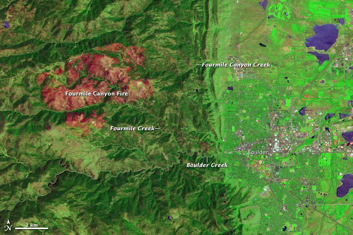
In September 2010, the Fourmile Canyon Fire broke out in the foothills west of Boulder, Colorado, scorching more than 6,000 acres (2,500 hectares) and forcing residents to evacuate. Ten months later, residents had to evacuate again, this time to flee floods. Stripped of vegetation, the slopes along Fourmile Canyon soaked up little of the water dropped by a thunderstorm. Instead, the runoff surged into local stream channels.
On June 7, 2011, the Advanced Land Imager (ALI) on NASA’s Earth Observing-1 (EO-1) satellite observed the Fourmile Canyon burn scar. The top image is made from a combination of shortwave infrared and visible light. The bottom image is natural color.
The scar is more easily detected in the false-color image, where the burned area appears in shades of red and orange. Creek valleys, which generally escaped the flames in September 2010, form winding corridors of green through the scar. To the east and southeast, the city of Boulder lies on relatively flat land.
After the fire, the U.S. Geological Survey (USGS) warned residents to prepare for the possibility of flooding, even from small rainstorms. Late on July 13, 2011, such a storm occurred. As rain fell west of Boulder, Fourmile Creek rose rapidly. In fact, at one USGS gauge, the water discharge rate skyrocketed in a matter of minutes from 10 cubic feet per second to 350 cubic feet per second. The increased water flow translated into a 4-foot (1.2-meter) surge down the creek. Smaller surges followed later that night and over the next few days.
Fourmile Creek is a tributary of Boulder Creek, which flows eastward through the city. Water levels usually peak between mid-May and early July. But thanks to the melting of an unusually heavy snowpack, water levels on Boulder Creek were especially high when the July 13 thunderstorm struck. As residents in the Fourmile burn area were ordered to evacuate low-lying homes, emergency sirens also sounded in Boulder.
By late July 2011, water levels had receded along both the Fourmile and Boulder Creeks, although water levels in both remained above normal. Colorado’s monsoon season typically lasts from about mid-July to early September, so the possibility of more flooding remains.
Because of the angle of sunlight, these images may cause an optical illusion known as relief inversion.
References
Byars, M. (2011, July 13). Heavy rains hit Fourmile, prompt evacuations along Boulder Creek. Boulder Daily Camera. Accessed July 29, 2011.
Colorado Mountain Club. Protecting Yourself from Mountain Hazards. Accessed July 29, 2011.
Colorado Water Science Center. (2011, July 13). Video From Fourmile Creek at Orodell. USGS. Accessed July 29, 2011.
Colorado’s Surface Water Conditions. (2011, July 29). Boulder Creek at Boulder, Colorado. State of Colorado. Accessed July 29, 2011.
National Water and Climate Center. (2011, July 7). Weekly Report – Snowpack/Drought Monitor Update. U.S. Department of Agriculture. Accessed July 29, 2011.
National Water Information System. (2011, July 29). USGS 06727410 Fourmile Creek at Logan Mill Road near Crisman, Colorado. USGS. Accessed July 29, 2011.
National Water Information System. (2011, July 29). USGS 06727500 Fourmile Creek at Orodell, Colorado. USGS. Accessed July 29, 2011.
News staff. (2011, July 13). Thunderstorms pound area; flood sirens sound in Boulder. The Denver Post. Accessed July 29, 2011.
Ruddy, B.C., Stevens, M.R., Verdin, K.L., and Elliott, J.G. (2010). Probability and volume of potential postwildfire debris flows in the 2010 Fourmile burn area, Boulder County, Colorado: U.S. Geological Survey Open-File Report 2010–1244. Accessed July 29, 2011.
Snider, L. (2011, June 8). Boulder Creek swells as warm weather melts snowpack. Boulder Daily Camera. Accessed July 29, 2011.
NASA Earth Observatory image created by Jesse Allen and Robert Simmon, using EO-1 ALI data provided courtesy of the NASA EO-1 team and the United States Geological Survey. Caption by Michon Scott.


