


May 1st
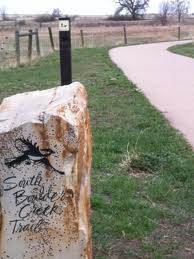 City of Boulder’s Open Space and Mountain Parks (OSMP) Department will begin seasonal area closures to protect grassland ground-nesting birds beginning Thursday, May 1.
These closures will be in effect until July 31.
No designated trails will be closed as part of this protective measure.
The areas closed for grassland ground-nesting birds are:
Both sides of the Greenbelt Plateau Trail from Community Ditch Trail to the Greenbelt Plateau Trailhead on state Highway 128. Dogs will be allowed on the Greenbelt Plateau only if they are on leash (the trail is normally voice-and-sight control);
The area north of Community Ditch Trail and west of state Highway 93;
The area north of the Flatirons Vista North Trail and west of Highway 93 on top of the mesa;
The area north of the South Boulder Creek West Trail, east of the Bluestem Connector and south of Shanahan Ridge (dogs are prohibited in this area year-round).
Dog regulations on both the Community Ditch and Doudy Draw trails will remain voice-and-sight control.
For a variety of reasons, grassland bird populations in North America have declined sharply in the last several decades. Three species that OSMP monitors – Grasshopper Sparrows, Horned Larks and Lark Sparrows – have suffered at least a 50-percent population decline in the last 40 years, according to the National Audubon Society. The closures OSMP will implement Thursday are important in protecting these species’ habitats by keeping people and their pets away as the birds attempt to nest.
Please help OSMP protect these species and other ground-nesting birds by respecting the closures. Trespass violations can result in a summons with penalties up to 90 days in jail and/or a $1,000 fine.
Source: City of Boulder

Mar 7th
Release Date: 02/28/2014
Contact Information: Hanady Kader, EPA Public Affairs, 206-553-0454, kader.hanady@epa.gov
Agency action begins process to prevent damage to world’s largest sockeye salmon fishery
(Washington, D.C.—Feb. 28, 2014) The U.S. Environmental Protection Agency is initiating a process under the Clean Water Act to identify appropriate options to protect the world’s largest sockeye salmon fishery in Bristol Bay, Alaska from the potentially destructive impacts of the proposed Pebble Mine. The Pebble Mine has the potential to be one of the largest open pit copper mines ever developed and could threaten a salmon resource rare in its quality and productivity. During this process, the U.S. Army Corps of Engineers cannot approve a permit for the mine.
This action, requested by EPA Administrator Gina McCarthy, reflects the unique nature of the Bristol Bay watershed as one of the world’s last prolific wild salmon resources and the threat posed by the Pebble deposit, a mine unprecedented in scope and scale. It does not reflect an EPA policy change in mine permitting.
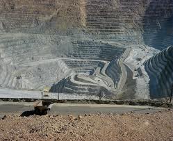
The Pebble Mine would be three times as large as the Kennecot mine pictured above
“Extensive scientific study has given us ample reason to believe that the Pebble Mine would likely have significant and irreversible negative impacts on the Bristol Bay watershed and its abundant salmon fisheries,” said EPA Administrator Gina McCarthy. “It’s why EPA is taking this step forward in our effort to ensure protection for the world’s most productive salmon fishery from the risks it faces from what could be one of the largest open pit mines on earth. This process is not something the Agency does very often, but Bristol Bay is an extraordinary and unique resource.”
The EPA is basing its action on available information, including data collected as a part of the agency’s Bristol Bay ecological risk assessment and mine plans submitted to the Securities and Exchange Commission. Today, Dennis McLerran, EPA Regional Administrator for EPA Region 10, sent letters to the U.S. Army Corps of Engineers, the State of Alaska, and the Pebble Partnership initiating action under EPA’s Clean Water Act Section 404(c) authorities.
“Bristol Bay is an extraordinary natural resource, home to some of the most abundant salmon producing rivers in the world. The area provides millions of dollars in jobs and food resources for Alaska Native Villages and commercial fishermen,” McLerran said. “The science EPA reviewed paints a clear picture: Large-scale copper mining of the Pebble deposit would likely result in significant and irreversible harm to the salmon and the people and industries that rely on them.”
Today’s action follows the January 2014 release of EPA’s “Assessment of Potential Mining Impacts on Salmon Ecosystems of Bristol Bay, Alaska,” a study that documents the significant ecological resources of the region and the potentially destructive impacts to salmon and other fish from potential large-scale copper mining of the Pebble Deposit. The assessment indicates that the proposed Pebble Mine would likely cause irreversible destruction of streams that support salmon and other important fish species, as well as extensive areas of wetlands, ponds and lakes.
In 2010, several Bristol Bay Alaska Native tribes requested that EPA take action under Clean Water Act Section 404(c) to protect the Bristol Bay watershed and salmon resources from development of the proposed Pebble Mine, a venture backed by Northern Dynasty Minerals. The Bristol Bay watershed is home to 31 Alaska Native Villages. Residents of the area depend on salmon as a major food resource and for their economic livelihood, with nearly all residents participating in subsistence fishing.
Bristol Bay produces nearly 50 percent of the world’s wild sockeye salmon with runs averaging 37.5 million fish each year. The salmon runs are highly productive due in large part to the exceptional water quality in streams and wetlands, which provide valuable salmon habitat.
The Bristol Bay ecosystem generates hundreds of millions of dollars in economic activity and provides employment for over 14,000 full and part-time workers. The region supports all five species of Pacific salmon found in North America: sockeye, coho, Chinook, chum, and pink. In addition, it is home to more than 20 other fish species, 190 bird species, and more than 40 terrestrial mammal species, including bears, moose, and caribou.
Based on information provided by The Pebble Partnership and Northern Dynasty Minerals, mining the Pebble deposit may involve excavation of a pit up to one mile deep and over 2.5 miles wide — the largest open pit ever constructed in North America. Disposal of mining waste may require construction of three or more massive earthen tailings dams as high as 650 feet. The Pebble deposit is located at the headwaters of Nushagak and Kvichak rivers, which produce about half of the sockeye salmon in Bristol Bay.
The objective of the Clean Water Act is to restore and maintain the chemical, physical, and biological integrity of the nation’s waters. The Act emphasizes protecting uses of the nation’s waterways, including fishing.
The Clean Water Act generally requires a permit under Section 404 from the U.S. Army Corps of Engineers before any person places dredge or fill material into wetlands, lakes and streams. Mining operations typically involve such activities and must obtain Clean Water Act Section 404 permits. Section 404 directs EPA to develop the environmental criteria the Army Corps uses to make permit decisions. It also authorizes EPA to prohibit or restrict fill activities if EPA determines such actions would have unacceptable adverse effects on fishery areas.
The steps in the Clean Water Act Section 404(c) review process are:
Based on input EPA receives during any one of these steps, the agency could decide that further review under Section 404(c) is not necessary.
Now that the 404(c) process has been initiated, the Army Corps cannot issue a permit for fill in wetlands or streams associated with mining the Pebble deposit until EPA completes the 404(c) review process.
EPA has received over 850,000 requests from citizens, tribes, Alaska Native corporations, commercial and sport fisherman, jewelry companies, seafood processors, restaurant owners, chefs, conservation organizations, members of the faith community, sport recreation business owners, elected officials and others asking EPA to take action to protect Bristol Bay.

Feb 27th
A new study led by the University of Colorado Boulder bolsters the theory that the first Americans, who are believed to have come over from northeast Asia during the last ice age, may have been isolated on the Bering Land Bridge for thousands of years before spreading throughout the Americas.
The theory, now known as the “Beringia Standstill,” was first proposed in 1997 by two Latin American geneticists and refined in 2007 by a team led by the University of Tartu in Estonia that sampled mitrochondrial DNA from more than 600 Native Americans. The researchers found that mutations in the DNA indicated a group of their direct ancestors from Siberia was likely isolated for at least several thousand years in the region of the Bering Land Bridge, the now-submerged plain that lies between northeast Asia and Alaska once exposed by a significantly lower sea level.
CU-Boulder researcher John Hoffecker, lead author of a short paper article appearing in the Feb. 28 issue of Science magazine, said the Beringia Standstill model gained little traction outside of the genetics community after it was proposed and has been seen by some scientists outside of the field as far-fetched. But the new paper by Hoffecker and co-authors Scott Elias of Royal Holloway, University of London, and Dennis O’Rourke of the University of Utah adds credence to the Beringia Standstill idea by further linking the genetics to the paleoecological evidence.
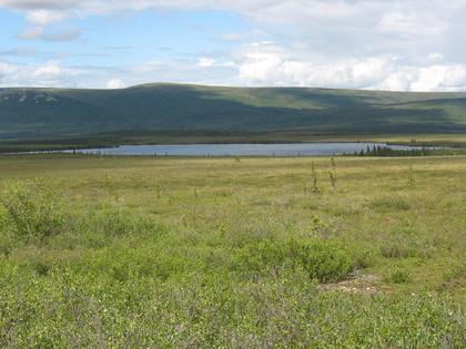
The Beringia Land Bridge was relatively temperate during the last ice age
“A number of supporting pieces have fallen in place during the last decade, including new evidence that central Beringia supported a shrub tundra region with some trees during the last glacial maximum and was characterized by surprisingly mild temperatures, given the high latitude,” said Hoffecker of CU-Boulder’s Institute of Arctic and Alpine Research. The last glacial maximum peaked roughly 21,000 years ago and was marked by the growth of vast ice sheets in North America and Europe.
While a debate rages on about when early humans first migrated into the New World, many archaeologists now believe it was sometime around 15,000 years ago after retreating glaciers opened access to coastal and interior routes into North America.
The relatively mild summer climate in Beringia at the time was caused by North Pacific circulation patterns that brought moist and relatively warm air to the region during the last glacial maximum. Geologists believe the Beringia gateway between Siberia and Alaska was more than 600 miles wide at the time.
Hoffecker and others are now theorizing that a population of hundreds or thousands of people parked itself in central Beringia for 5,000 years or more. One key to the extended occupation may have been the presence of wood in some places to use as a fuel to supplement bone, which burns hot and fast. Experiments have shown that at least some wood is necessary to make bone practical as a fuel.
Elias, a paleoecologist and also an INSTAAR affiliate, said research using fossil pollen, plant and insect material from sediment cores from the now submerged landscape show that the Bering Land Bridge tundra environment contained enough woody plants and trees like birch, willow and alder to provide a supplement to bone.
Work by Elias and others included the analysis of certain beetle species that live in very specific temperature zones, allowing them to be used as tiny thermometers. The insects indicated that temperatures there were relatively mild during last glacial maximum that ran from about 27,000 years to 20,000 years ago, only slightly cooler than temperatures in the region today.
“The climate on the land bridge and adjacent parts of Siberia and Alaska was a bit wetter than the interior regions like central Alaska and the Yukon, but not a lot warmer,” said Elias. “Our data show that woody shrubs were available on the land bridge, which would have facilitated the making of fires by the people there.”
Evidence from the 2007 study indicated a set of genetic mutations in mitochondrial DNA, which is passed down from mother to offspring, clearly accumulated after the divergence of people from their Asian parent groups in Siberia but before their dispersal throughout the Western Hemisphere, said O’Rourke. In addition, ancient DNA from human skeletal remains found at a 24,000-year-old archaeological site in southern Siberia also appears consistent with the divergence of Native American groups from their Asian forbearers by that time window, he said.
“The genetic record has been very clear for several years that the Native American genome must have arisen in an isolated population at least by 25,000 years ago, and the bulk of the migrants to the Americas really didn’t arrive south of the ice sheets until nearly 15,000 years ago,” O’Rourke said. “The paleoecological data, which I think most geneticists have not been familiar with, indicate that Beringia was not a uniform environment, and there was a shrub tundra region, or refugium, that likely provided habitats conducive to continuous human habitation.”
“From my view the genetics and paleoecology data come together nicely,” said Hoffecker, who co-authored a 2007 book with Elias titled “The Human Ecology of Beringia.” While the weakest link to the Out of Beringia theory is the lack of archaeological evidence, Hoffecker believes future research on now submerged parts of Beringia as well as lowlands in western Alaska and eastern Siberia that still remain above water may hold clues to ancient habitation by Beringia residents, who eventually moved on to be the first group to inhabit the Americas.
Hoffecker also believes that the Beringia inhabitants during the last glacial maximum could have made successful hunting forays into the uninhabited steppe-tundra region to both the east and west, where drier conditions and more grass supported a plentiful array of large grazing animals, including steppe bison, horse and mammoth.
There is now solid evidence for humans in Beringia before the last glacial maximum, as geneticists first predicted in 1997, said Hoffecker. After the maximum, there are two sets of archaeological remains dating to less than 15,000 years ago. “One represents a late migration from Asia into Alaska at that time,” he said. “The other has no obvious source outside Beringia and may represent the people who are thought to have sheltered on the land bridge during the glacial maximum.
“If we are looking for a place to put all of these people during the last glacial maximum, Beringia may be the only realistic option,” said Hoffecker.
A video news story on the research is available at http://www.colorado.edu/news.
-CU-


