


News from Boulder, Colorado and Boulder Channel 1 News editors To advertise please call 303-447-8531
Nov 12th
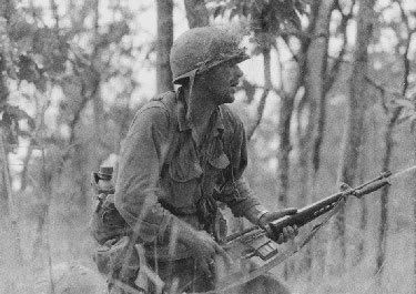 Ia Drang Valley is an exception to the rule. If you were alive and paying attention (or were able to) the battle was presented in the movie “We Were Soldiers Once” based on the book “We Were Soldiers Once. . . And Young” coauthored by LTG Hal Moore and Joe Galloway a civilian combat photographer who was awarded the Bronze Star with V device for his actions at Ia Drang. (Galloway was the only reporter in the war to be so honored.)
The legacy of the veterans of the Ia Drang Valley battle is best described in one word – profound. The soldier on the cover of “We Were Soldiers Once. . . And Young” is (then) 1LT Ric Rescola from Cornwall England who served in the British army in Rhodesia (present Zimbabwe). After his service to Queen and Country, Rescola moved to the US. After being in the States long enough to become eligible, he enlisted in the US Army and later graduated Officer Candidate School (OCS), served in Vietnam and was a platoon leader in this battle. After his active army service, he became a career reservist and retired as a Colonel. At Ia Drang Rescola would sing Cornish songs to keep his men inspired and motivated during the dark of night.
Who would have guessed 36 years later, it would be the same man, who as vice president of security for Merrill Lynch, would last be seen going up the tenth floor stairway of Tower 2 on September 11, 2001 to bring more people out of the crumbling, massive building. His remains were never recovered.
Then there are Major Bruce (Snake shi+) Crandall and Captain Ed (Too Tall) Freeman, who repeatedly flew their bullet riddled and unarmed Huey UH-1D’s to LZ X-ray, delivering desperately needed water, medical supplies, and ammunition under heavy fire. Unloading supplies and simultaneously loading wounded soldiers and returning 22 and 21 times respectively in one day. Their citations do not reflect the whole story or their total contribution to the men of the 7th Cavalry.
Crandall & Freeman voluntarily assumed the medevac role when the medevac unit refused to fly into the hot LZ. Crandall had to fly three separate Huey’s, two had been shot up so bad they would not remain airborne. On his final flight of the first day, he carried reporter & photographer Joe Galloway into the battle.
Joe Galloway was awarded the Bronze Star with V device for his service in the battle. He is the only reporter who covered the war recognized for heroism in combat.
Colonel Crandall broke his back when he crash landed a year later while rescuing 12 trapped soldiers. Ironically, it was the concussion from a B52 strike that felled his Huey. In 2001, when he discovered he and Ed Freeman were both being considered for the same Medal of Honor, Colonel Crandall asked that his name be removed to make way for his wing man, should the medal be awarded.
Captain Ed Freeman was awarded a battlefield commission in Korea for his actions in the Battle of Pork Chop Hill. He stands 6’6″ and was too tall for helicopter training without a waiver, which was granted somehow. If you know about army waivers, they don’t come easily. At Ia Drang, he volunteered to fly in combat with Crandall, saving over 30 soldiers lives.
Lieutenant Walter Marm, while leading his platoon through withering fire attacked a defended enemy position, and when out of hand grenades and ammunition, he pressed his attack by hand while severely wounded. Lieutenant Marm was awarded the Medal of Honor in 1967. He later returned to Vietnam and retired from the Army as Colonel.
These men are loved by their families, friends, and fellow soldiers. They all deserved better when they returned home than what they received.
Their citations are presented here in the order awarded.

Nov 11th
“You are the subject member in the investigation because it is your behavior that created probable cause to believe you violated several laws, including city ordinance 5-5-1(a) Obstructing Government Operations; C.R.S. 18-9-108, Disrupting Lawful Assembly; and 18-9-110, Public Buildings – trespass, interference. Our investigation will document what occurred, what violations occurred, and what warnings were provided (letter from City Manager). Any future criminal behavior on your part will likely result in more”than just a warning.”
Brigham has also received a letter from the city manager telling him he was being investigated. Mayor Susan Osborne also wrote to Brigham telling him ” there were consequences”
“Please do not continue to copy the Boulder County ACLU on these messages regarding Seth Brigham.
The ACLU has no information about this incident. We do not represent Mr. Brigham or speak for him. The ACLU takes no position on his conduct which is the subject of this email thread or the law enforcement response thereto. However, as we have repeatedly stated: The ACLU urges Council to make needed changes in the rules of decorum for public participation as has been proposed to Council by the City Attorney.”Brigham has admittedly suffered from mental health problems, but his recent appearances at Council have him drunk and disorderly according to witness’s.
As a point of disclosure Seth Brigham has been a contributor to Boulder Channel 1 news. This story is about him, not by him.
Nov 10th
Taylor, a CU-Boulder senior, joins student leaders from Harvard, Stanford, the Massachusetts Institute of Technology, Georgetown and several other universities. The trip is designed to better acquaint future U.S. leaders with Russia and give them insight into Russian leaders’ decision-making processes.
“I am very excited to participate in this unique and groundbreaking opportunity,” Taylor said. “I look forward to working with fellow student leaders to learn more about Russian government and culture and also share our American perspectives with our hosts. I am honored to have the chance to meet with high-ranking Russian officials and students and am confident that it will be an educational experience for all involved.”
While there, Taylor and the other students will meet with top Russian leaders of all branches of government, visit Russia’s top universities and meet with their Russian counterparts. The trip is completely funded by the Russian Federal Agency on Youth Affairs.
Taylor was selected for the trip through a competitive process that sought university student leaders expected to help shape future U.S. policies.
SOURCE: CU MEDIA RELEASE


