


Jan 18th
8:20 pm Power lines down on Pennsylvania on hill
8:25pm Tree down at 9th and college impeding traffic
Tiles flying off down town church at Broadway and Spruce
8:45pm Boulder County reports power line down in field at redwood court, sparking with fire and embers.
all fires out at this point, but police report signs, debris flying through air. Power lines are down and there are still power outages.
9:00pm Boulder Airport reports constant wind speed of 54mph Various sources in city report gusts of 71mph to 92mph
Diagonal and Look out road RR crossing sign blew into car causing tow car accident.
9:27pm Boulder Weather Station live reposts Power lines and trees continue to fall at this hour.
High Wind Warning
.HIGH WINDS IN THE MOUNTAINS AND FOOTHILLS THROUGH THURSDAY MORNING…
.VERY STRONG WEST WINDS WILL CONTINUE OVER THE NORTHERN COLORADO
MOUNTAINS…FOOTHILLS AND ADJACENT PLAINS THROUGH THURSDAY
MORNING. THE HIGH WIND WARNING IN THE MOUNTAINS HAS BEEN UPGRADED TO A
BLIZZARD WARNING FOR THE REST OF TONIGHT AS SNOW WILL DEVELOP ALONG
WITH THE CONTINUED WIND.
WIND GUSTS FROM 70 TO 90 MPH WILL BE COMMON IN WIND PRONE
MOUNTAIN AND FOOTHILL AREAS…AND ALSO IN FAVORED AREAS JUST EAST
OF THE MOUNTAINS SUCH AS ROCKY FLATS…BOULDER…AND CARTER LAKE.
THE STRONG WINDS WILL LIKELY CAUSE DOWNED TREES…POWER OUTAGES…
AND MAY BLOW OVER HIGH PROFILE AND LIGHT WEIGHT VEHICLES.
MONITOR THE LATEST WEATHER CONDITIONS AND AVOID TRAVEL IN AREAS
EXPERIENCING VIOLENT WINDS. MAIN AREAS LIKELY TO BE AFFECTED ARE
INTERSTATE 70 IN JEFFERSON AND CLEAR CREEK COUNTIES…THE PEAK TO
PEAK HIGHWAY BETWEEN BLACK HAWK AND ESTES PARK…AND HIGHWAYS AT
THE BASE OF THE FOOTHILLS.
Aug 2nd
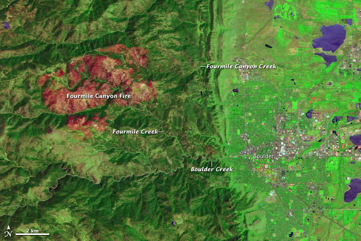
In September 2010, the Fourmile Canyon Fire broke out in the foothills west of Boulder, Colorado, scorching more than 6,000 acres (2,500 hectares) and forcing residents to evacuate. Ten months later, residents had to evacuate again, this time to flee floods. Stripped of vegetation, the slopes along Fourmile Canyon soaked up little of the water dropped by a thunderstorm. Instead, the runoff surged into local stream channels.
On June 7, 2011, the Advanced Land Imager (ALI) on NASA’s Earth Observing-1 (EO-1) satellite observed the Fourmile Canyon burn scar. The top image is made from a combination of shortwave infrared and visible light. The bottom image is natural color.
The scar is more easily detected in the false-color image, where the burned area appears in shades of red and orange. Creek valleys, which generally escaped the flames in September 2010, form winding corridors of green through the scar. To the east and southeast, the city of Boulder lies on relatively flat land.
After the fire, the U.S. Geological Survey (USGS) warned residents to prepare for the possibility of flooding, even from small rainstorms. Late on July 13, 2011, such a storm occurred. As rain fell west of Boulder, Fourmile Creek rose rapidly. In fact, at one USGS gauge, the water discharge rate skyrocketed in a matter of minutes from 10 cubic feet per second to 350 cubic feet per second. The increased water flow translated into a 4-foot (1.2-meter) surge down the creek. Smaller surges followed later that night and over the next few days.
Fourmile Creek is a tributary of Boulder Creek, which flows eastward through the city. Water levels usually peak between mid-May and early July. But thanks to the melting of an unusually heavy snowpack, water levels on Boulder Creek were especially high when the July 13 thunderstorm struck. As residents in the Fourmile burn area were ordered to evacuate low-lying homes, emergency sirens also sounded in Boulder.
By late July 2011, water levels had receded along both the Fourmile and Boulder Creeks, although water levels in both remained above normal. Colorado’s monsoon season typically lasts from about mid-July to early September, so the possibility of more flooding remains.
Because of the angle of sunlight, these images may cause an optical illusion known as relief inversion.
References
Byars, M. (2011, July 13). Heavy rains hit Fourmile, prompt evacuations along Boulder Creek. Boulder Daily Camera. Accessed July 29, 2011.
Colorado Mountain Club. Protecting Yourself from Mountain Hazards. Accessed July 29, 2011.
Colorado Water Science Center. (2011, July 13). Video From Fourmile Creek at Orodell. USGS. Accessed July 29, 2011.
Colorado’s Surface Water Conditions. (2011, July 29). Boulder Creek at Boulder, Colorado. State of Colorado. Accessed July 29, 2011.
National Water and Climate Center. (2011, July 7). Weekly Report – Snowpack/Drought Monitor Update. U.S. Department of Agriculture. Accessed July 29, 2011.
National Water Information System. (2011, July 29). USGS 06727410 Fourmile Creek at Logan Mill Road near Crisman, Colorado. USGS. Accessed July 29, 2011.
National Water Information System. (2011, July 29). USGS 06727500 Fourmile Creek at Orodell, Colorado. USGS. Accessed July 29, 2011.
News staff. (2011, July 13). Thunderstorms pound area; flood sirens sound in Boulder. The Denver Post. Accessed July 29, 2011.
Ruddy, B.C., Stevens, M.R., Verdin, K.L., and Elliott, J.G. (2010). Probability and volume of potential postwildfire debris flows in the 2010 Fourmile burn area, Boulder County, Colorado: U.S. Geological Survey Open-File Report 2010–1244. Accessed July 29, 2011.
Snider, L. (2011, June 8). Boulder Creek swells as warm weather melts snowpack. Boulder Daily Camera. Accessed July 29, 2011.
NASA Earth Observatory image created by Jesse Allen and Robert Simmon, using EO-1 ALI data provided courtesy of the NASA EO-1 team and the United States Geological Survey. Caption by Michon Scott.
Jun 30th
Boulder County, Colo. – The Boulder County Forest Health Initiative invites Nederland-area residents to attend a community meeting to discuss the first year of operations of the Nederland Area Community Forestry Sort Yard program.
What: Community meeting for residents to provide input on operations at the Nederland Area Community Forestry Sort Yard
When: Tuesday, July 12, 7 p.m.
Where: Nederland Community Center, 750 Highway 72 North
The sort yard was opened this year as a new service for residents in the Nederland area, and the county wants to make sure it is providing residents with the most useful, best practices possible for collecting and processing logs and slash cut from their lands.
County staff will kick off the meeting with a presentation about sort yard usage, total days of operation and the amount of material collected during the first year of operation. The second part of the meeting will focus on gathering public feedback about how the first year of operations went for residents in the Nederland community.
No RSVP is needed to attend. Community members may email comments and suggestions prior to the meeting to pinebeetle@bouldercounty.org.
The Community Forestry Sort Yard program was established by Boulder County to help landowners fight bark beetle infestations, create better defensible space around homes and communities and to help create healthier forest conditions in the foothills of the county. Two sort yard locations are open each summer on a rotating schedule to provide residents a convenient free of charge location to dispose of logs and slash cut from their land.
For more information about the program, bark beetle management or general questions backyard forest management, contact Boulder County Outreach Forester Ryan Ludlow at 720-564-2641 or pinebeetle@bouldercounty.org.


