


Aug 19th
In 1991, when Punam Chatterjee was 20 months old, a drunk driver careened into her parents’ car. Her leg was shattered, as was her father’s. Her mother lost an eye. Although she was too young to remember it, she has since learned that while her parents convalesced, nurses volunteered to comfort her and read to her.
“I don’t know any of those people … but what they did for me was just incredible,” Chatterjee recalled.
She still has multiple screws in her leg, and while she said she’s “never going to try out for the Army,” she is active. And she is ambitious: “I want to be a doctor and help children who went through what I did.”
Throughout her education at the University of Colorado Boulder, the Elevations Credit Union Buffalo BicycleClassic has helped Chatterjee pursue her dream. She graduated in May with degrees in psychology and neuroscience plus molecular, cellular and developmental biology.
Chatterjee is one of the hundreds of recipients of $1.4 million in scholarship money raised by CU’s Buffalo Bicycle Classic since its founding in 2003.
The event is the brainchild of Todd Gleeson, dean of CU’s College of Arts and Sciences, and Woody Eaton, a 1962 alumnus, businessman, investor and philanthropist. The pair hatched the idea of a fundraising ride for scholarships while cycling together in support of The Children’s Hospital.
Gleeson and Eaton enlisted the help of Frank Banta and Gail Mock of Boulder. Banta, of Banta Construction, is a 1972 alumnus, and Mock, of Mock Realty, is a longtime university supporter. The event is organized and overseen by volunteers.
The event has generated 548 scholarships for good students who need financial support. Students cannot apply for the scholarship and don’t even know they’re in the running until they learn they have won. It is the single largest source of scholarships in theCollege of Arts and Sciences, which is the largest of the university’s colleges and schools.
The event was canceled last year because of the Fourmile Canyon Fire, but because most riders and sponsors did not request a refund, scholarships remained funded.
Scholarship recipients call it a significant windfall.
Leslie Fowler, a current scholarship recipient majoring in classics, put it this way: “I am so grateful to have been selected as a BBC scholar because it makes me feel more confident about paying my student loans after graduation. It makes me feel that much closer to having my dream job as a high school teacher.”
Cyclists of all ages and abilities are gearing up for this year’s Elevations Credit Union Buffalo Bicycle Classic on Sept. 11 in Boulder. Ambitious cyclists can ride the 100-mile, 70-mile, 50-mile or 35-mile rides. More casual riders, including families and recreational riders, are encouraged to ride the 14-mile Little Buffalo, which will include snow cones and complimentary face paintings.
Riders are encouraged to register early, as the ride will be capped at 2,500 cyclists, a number the ride has attracted in recent years.
All cyclists participating in this fully supported, fundraising ride will generate scholarship funds. Online registration of $95 for the longer rides includes a scholarship donation of$45. Registration for the Little Buffalo is $65 for participants 14 and older and $35 for riders from 8 to 13.
Those who “Ride the Buffalo” will start and finish on the CU-Boulder campus at Benson Field, located across Colorado Avenue from Folsom Field. The longer courses traverse through Boulder and Larimer counties. The 14-mile Little Buff is a fun cruiser ride around Boulder to the town of Marshall; it is perfect for those who want to participate but don’t want to face long courses and busy roads.
Registration for all rides includes a Ride the Buffalo T-shirt, water bottle, aid-station treats, breakfast and lunch. Jerseys, socks and other merchandise are available separately. An expo featuring sponsors will be held at the start/finish, and riders can win raffle prizes and enjoy after-race food, beverages and entertainment.
Riders can register online at http://www.buffalobicycleclassic.com. Walk-up registration is available the day of the ride and includes a $10 late fee. For information call 303-735-1569 or email bbc@colorado.edu.
Aug 2nd
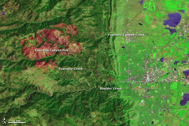
In September 2010, the Fourmile Canyon Fire broke out in the foothills west of Boulder, Colorado, scorching more than 6,000 acres (2,500 hectares) and forcing residents to evacuate. Ten months later, residents had to evacuate again, this time to flee floods. Stripped of vegetation, the slopes along Fourmile Canyon soaked up little of the water dropped by a thunderstorm. Instead, the runoff surged into local stream channels.
On June 7, 2011, the Advanced Land Imager (ALI) on NASA’s Earth Observing-1 (EO-1) satellite observed the Fourmile Canyon burn scar. The top image is made from a combination of shortwave infrared and visible light. The bottom image is natural color.
The scar is more easily detected in the false-color image, where the burned area appears in shades of red and orange. Creek valleys, which generally escaped the flames in September 2010, form winding corridors of green through the scar. To the east and southeast, the city of Boulder lies on relatively flat land.
After the fire, the U.S. Geological Survey (USGS) warned residents to prepare for the possibility of flooding, even from small rainstorms. Late on July 13, 2011, such a storm occurred. As rain fell west of Boulder, Fourmile Creek rose rapidly. In fact, at one USGS gauge, the water discharge rate skyrocketed in a matter of minutes from 10 cubic feet per second to 350 cubic feet per second. The increased water flow translated into a 4-foot (1.2-meter) surge down the creek. Smaller surges followed later that night and over the next few days.
Fourmile Creek is a tributary of Boulder Creek, which flows eastward through the city. Water levels usually peak between mid-May and early July. But thanks to the melting of an unusually heavy snowpack, water levels on Boulder Creek were especially high when the July 13 thunderstorm struck. As residents in the Fourmile burn area were ordered to evacuate low-lying homes, emergency sirens also sounded in Boulder.
By late July 2011, water levels had receded along both the Fourmile and Boulder Creeks, although water levels in both remained above normal. Colorado’s monsoon season typically lasts from about mid-July to early September, so the possibility of more flooding remains.
Because of the angle of sunlight, these images may cause an optical illusion known as relief inversion.
References
Byars, M. (2011, July 13). Heavy rains hit Fourmile, prompt evacuations along Boulder Creek. Boulder Daily Camera. Accessed July 29, 2011.
Colorado Mountain Club. Protecting Yourself from Mountain Hazards. Accessed July 29, 2011.
Colorado Water Science Center. (2011, July 13). Video From Fourmile Creek at Orodell. USGS. Accessed July 29, 2011.
Colorado’s Surface Water Conditions. (2011, July 29). Boulder Creek at Boulder, Colorado. State of Colorado. Accessed July 29, 2011.
National Water and Climate Center. (2011, July 7). Weekly Report – Snowpack/Drought Monitor Update. U.S. Department of Agriculture. Accessed July 29, 2011.
National Water Information System. (2011, July 29). USGS 06727410 Fourmile Creek at Logan Mill Road near Crisman, Colorado. USGS. Accessed July 29, 2011.
National Water Information System. (2011, July 29). USGS 06727500 Fourmile Creek at Orodell, Colorado. USGS. Accessed July 29, 2011.
News staff. (2011, July 13). Thunderstorms pound area; flood sirens sound in Boulder. The Denver Post. Accessed July 29, 2011.
Ruddy, B.C., Stevens, M.R., Verdin, K.L., and Elliott, J.G. (2010). Probability and volume of potential postwildfire debris flows in the 2010 Fourmile burn area, Boulder County, Colorado: U.S. Geological Survey Open-File Report 2010–1244. Accessed July 29, 2011.
Snider, L. (2011, June 8). Boulder Creek swells as warm weather melts snowpack. Boulder Daily Camera. Accessed July 29, 2011.
NASA Earth Observatory image created by Jesse Allen and Robert Simmon, using EO-1 ALI data provided courtesy of the NASA EO-1 team and the United States Geological Survey. Caption by Michon Scott.
Jul 8th
It was continuing to rain. The slides get larger as you continue past mile marker 8. Even in our 4 wheel drive TV production SUV we could only make it to the second slide. The command center gave us an escort from Four Mile Fire department. We had to have a radio person with us in case it slid again and we got caught up in a slide.
Initially, a Boulder County Sheriff deputy came up on the slides during the down pour at around 6:00pm. He told us it was all he could do to drive out in his Sheriffs big SUV Chevy.
Four Mile fire chief said that a large amount of the slide had hung up about 50 feet up the hill on a rock out cropping. There was some concern that it would slide again on into the night as the rains continued.
Four Mile Fire was on the scene and stationed through out the canyon to watch for more slides. A large road grader was pushing dirt and a front end loader and 10 Wheel dump truck were working the larger slides.
The hope is to get the road opened by morning. The concern is that it will keep raining and cause major slides.
Flash flood warning in Fourmile Canyon in effect until 9:15 p.m.
Thursday, July 07, 2011
Boulder County, Colo. – Boulder Canyon and the Fourmile Canyon areas are under a National Weather Service Flash Flood Warning until 9:15 tonight. The fire protection districts and communities in the Fourmile Canyon Fire burn area are on high alert and closely monitoring events and responding to hazardous conditions.
Heavy rainfall occurred in the canyons around 6 p.m., and the Fourmile Creek reached peak flow around 7 p.m., but the creek did not overbank. Creek flows are now receding and water levels are dropping in the Fourmile Creek and Boulder Creek in Boulder Canyon.
Fourmile Canyon Drive is closed to travel due to mud, rock and debris flows between blocks 5900 and 8000 (Wall St. area). Lefthand Canyon and other roads in the area have had minor rock slides, but are passable. Motorists are urged to use caution on all roadways impacted by water flows and rock slides.
Sheriff’s deputies and emergency services personnel are on patrol in the Fourmile Canyon and Lefthand Canyon areas. They are checking creek water levels and monitoring the passage of roads. The Boulder Emergency Operations Center has been activated and continues to monitor weather, road and community conditions.
Reverse notification messages were sent to approximately 300 residences telling them to remain on alert and be prepared to seek higher ground.
10:30 p.m. – EOC deactivating; severe weather clearing out of area
The storm systems are tracking to the south and the risk appears to be low for the Fourmile Area, but not completely gone. Storms are expected to continue all night with diminished intensity and a southerly track. The flash flood warning has ended and all residents have returned to homes.
Another everbridge was sent to advise residents that the flash flood warning has expired but to remain vigilant due to weather still in the area. The only road closure presently is west of Emerson Gulch (off Fourmile Canyon Dr.) and is 4 feet deep and 100 yards wide. County road crews are building an emergency access through it and will go to work on removal of debris tomorrow.
The Emergency Operations Center will deactivate at 10:30 p.m
7/7 – 9:12 p.m. – Crews On Scene Clearing Roads
7/7 – 9:12 p.m. – County road maintenance crews are on scene with plows and road graders clearing the rock slides and debris flows. The goal is to get one passable lane in Fourmile Canyon tonight and go back tomorrow to widen the road.
7/7 – 8:39 p.m – Damage Assesment
7/7 – 8:39 p.m. – There are no reports of structure or infrastructure damage, other than debris flows on roads in the Fourmile area. Electricity and phones are working. No injuries have been reported.
7/7 – 8:30 p.m. – Downstream Impacts
Levels in Boulder Creek have peaked and are receding. Underpasses could be flooded. Some street flooding, but no imminent danger to City of Boulder. Use caution on roads and paths.
7/7 – 8:15 p.m. – Road Closure Update
7/7 – 8:15 p.m. – Fourmile Canyon still closed between 5900 and 8000 blocks (Wall Street area). Gold Run, Gold Hill and Lickskillit are open. Lefthand Canyon and Boulder Canyon have some rocks on the road, but are passable.
7/7 – 8:07 pm. – Assessment of Area
7/7 – 8:07 p.m. – Sheriff’s deputies are in the Fourmile and Lefthand Canyon area. They are checking creek water levels and the passability of roads.
7/7 – 8 p.m. Reverse Notification Sent
Reverse notification messages and phone calls sent to approximately 300 residences telling them to remain on alert and be prepared to seek higher ground. The National Weather Service has a flash flood warning in effect until 9:15 p.m.
Road Closures
7/7 – 7:51 p.m. – Fourmile is closed at 5900 block. Traffic westbound needs to find an alternate route. There are rock slides in Lefthand Canyon and Boulder Canyon, but they are passable. Please use caution when on these roads. County road crews and Colorado State Patrol enroute to assess and clear.
Lefthand Canyon has some minor rock slides. Roads are passable, but use caution.
7/7 7 p.m. – Flash Flood Warning in Fourmile Burn Area
A Flash Flood Warning is in effect in the Fourmile Burn Area. Intense storms are expected to continue moving through the area.


