


Aug 2nd
In September 2010, the Fourmile Canyon Fire broke out in the foothills west of Boulder, Colorado, scorching more than 6,000 acres (2,500 hectares) and forcing residents to evacuate. Ten months later, residents had to evacuate again, this time to flee floods. Stripped of vegetation, the slopes along Fourmile Canyon soaked up little of the water dropped by a thunderstorm. Instead, the runoff surged into local stream channels.
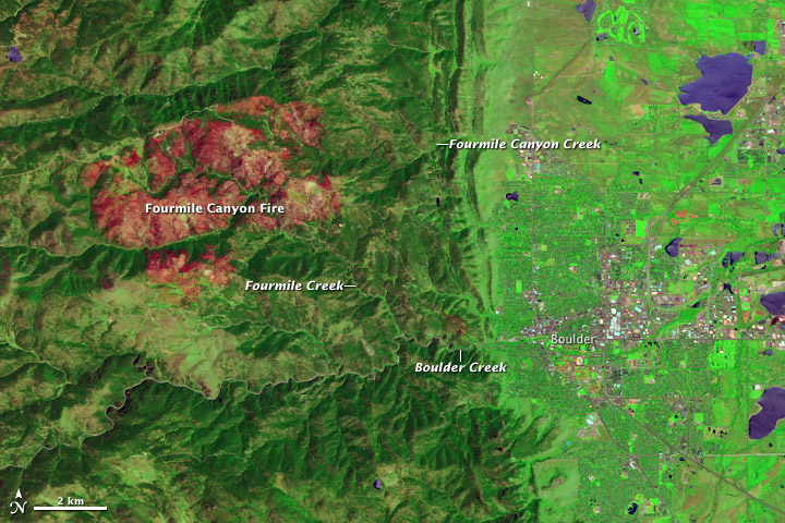
On June 7, 2011, the Advanced Land Imager (ALI) on NASA’s Earth Observing-1 (EO-1) satellite observed the Fourmile Canyon burn scar. The top image is made from a combination of shortwave infrared and visible light. The bottom image is natural color.
The scar is more easily detected in the false-color image, where the burned area appears in shades of red and orange. Creek valleys, which generally escaped the flames in September 2010, form winding corridors of green through the scar. To the east and southeast, the city of Boulder lies on relatively flat land.
After the fire, the U.S. Geological Survey (USGS) warned residents to prepare for the possibility of flooding, even from small rainstorms. Late on July 13, 2011, such a storm occurred. As rain fell west of Boulder, Fourmile Creek rose rapidly. In fact, at one USGS gauge, the water discharge rate skyrocketed in a matter of minutes from 10 cubic feet per second to 350 cubic feet per second. The increased water flow translated into a 4-foot (1.2-meter) surge down the creek. Smaller surges followed later that night and over the next few days.
Fourmile Creek is a tributary of Boulder Creek, which flows eastward through the city. Water levels usually peak between mid-May and early July. But thanks to the melting of an unusually heavy snowpack, water levels on Boulder Creek were especially high when the July 13 thunderstorm struck. As residents in the Fourmile burn area were ordered to evacuate low-lying homes, emergency sirens also sounded in Boulder.
By late July 2011, water levels had receded along both the Fourmile and Boulder Creeks, although water levels in both remained above normal. Colorado’s monsoon season typically lasts from about mid-July to early September, so the possibility of more flooding remains.
Because of the angle of sunlight, these images may cause an optical illusion known as relief inversion.
References
Byars, M. (2011, July 13). Heavy rains hit Fourmile, prompt evacuations along Boulder Creek. Boulder Daily Camera. Accessed July 29, 2011.
Colorado Mountain Club. Protecting Yourself from Mountain Hazards. Accessed July 29, 2011.
Colorado Water Science Center. (2011, July 13). Video From Fourmile Creek at Orodell. USGS. Accessed July 29, 2011.
Colorado’s Surface Water Conditions. (2011, July 29). Boulder Creek at Boulder, Colorado. State of Colorado. Accessed July 29, 2011.
National Water and Climate Center. (2011, July 7). Weekly Report – Snowpack/Drought Monitor Update. U.S. Department of Agriculture. Accessed July 29, 2011.
National Water Information System. (2011, July 29). USGS 06727410 Fourmile Creek at Logan Mill Road near Crisman, Colorado. USGS. Accessed July 29, 2011.
National Water Information System. (2011, July 29). USGS 06727500 Fourmile Creek at Orodell, Colorado. USGS. Accessed July 29, 2011.
News staff. (2011, July 13). Thunderstorms pound area; flood sirens sound in Boulder. The Denver Post. Accessed July 29, 2011.
Ruddy, B.C., Stevens, M.R., Verdin, K.L., and Elliott, J.G. (2010). Probability and volume of potential postwildfire debris flows in the 2010 Fourmile burn area, Boulder County, Colorado: U.S. Geological Survey Open-File Report 2010–1244. Accessed July 29, 2011.
Snider, L. (2011, June 8). Boulder Creek swells as warm weather melts snowpack. Boulder Daily Camera. Accessed July 29, 2011.
NASA Earth Observatory image created by Jesse Allen and Robert Simmon, using EO-1 ALI data provided courtesy of the NASA EO-1 team and the United States Geological Survey. Caption by Michon Scott.
Jul 13th
7/14 2:56 p.m. Impacts to Ann U. White Trail/Wagon Wheel Gap Road
Water is currently running down Ann U. White Trail and rising quickly. Wagon Wheel Gap Road (off Lee Hill Road) may be affected because of trail drainage.
7/14 2:21 Call center now open
A public information call center is now open. Call 303-413-7730 for updates on today/tonight’s weather event and related emergency information.
7/14 2:12 p.m. – Rock slide on Boulder Canyon Highway 119
A rock slide has occurred on Highway 119 at approximately mile marker 35. The westbound lane is completely closed. The Boulder County Sheriffs Office and the Colorado Department of Transportation are en route to respond. Motorists can expect delays; alternate routes are advised.
7/14 1:10 p.m. – FLASH FLOOD WARNING for Fourmile Fire burn area
The National Weather Service has issued a FLASH FLOOD WARNING for the Fourmile Fire burn area effect immediately.
Prepare for possible flooding and take appropriate actions in low lying and heavy drainage areas for Fourmile Creek and Fourmile Canyon Creek.
The Boulder Emergency Operations Center is activated and providing support to field emergency operations.
Further information will be provided as it becomes available.
7/14 10:30 a.m. – Anne U. White Trail in north Boulder area is closed due to flooding
The Anne U. White Trail (which follows follows the Four Mile Canyon Creek in an area near north Boulder) was closed last night by the Sheriff’s office due to flooding. The trailhead is located off Wagonwheel Gap Road and Lee Hill Road.
Continued flash flood warnings in the trailhead area are expected throughout the day today. Damage to the trail, including wash-outs and log jams may require the trail to remain closed for longer for repairs.
Updates will be made available as repair assessments and time frames can be estimated by the Boulder County open space trails staff.
7/14 9:10 a.m. – Current status of Fourmile Fire burn area after last night’s storm activity
Boulder County Road Maintenance crews are in the area clearing roads and culverts. All roads are open with the exception of Fourmile Canyon from Poorman Road to Gold Run Road and Gold Run Road to Dixon Road. Even though the other roads are passable, people are being asked to proceed with caution because of the debris remaining on the roads.
This morning, deputies and firefighters are in the Fourmile burn area assisting residents and assessing damages. There have been reports of a number of structures (both residences and outbuildings) and vehicles that were damaged by the rising water and debris flows. The reports indicate that these occurrences were throughout the burn area and not in any one isolated location. At this time, we do not have any estimates of the total cost of damages from these storms.
The weather forecast for today is predicted to be similar to the weather patterns we experienced yesterday (July 13, 2011). Residents living in the Fourmile burn area need to remain alert and cognizant of the potential for additional flooding.
7/14 9 a.m. – Notice about water quality after heavy rainfall
Heavy rainfall increases the flow of sediment into our local streams and creeks, increasing the cloudiness of water. As a result of recent heavy rainfall over the Four Mile burn area, this sediment has been significant, contributing to a temporary discoloration of Fourmile Creek and Boulder Creek.
The cloudiness and discoloration is an indicator of poor water quality and can mean an increased level of pathogens, such as E. coli and Giardia. People should always avoid drinking untreated and unfiltered water from streams, creeks, lakes, etc. Cloudy, fast-moving water may also have hidden debris that poses a safety risk, so people should avoid recreational activity in the creeks after heavy rainfalls or, at a minimum, exercise extreme caution.
Treatment plants for drinking water are designed to remove sediment and disinfect the water against pathogens, so the cloudy stream is not a concern for tap water. The City of Boulder does not draw any of its drinking water from these creeks.
7/14 1:10 a.m. – Secondary surge has occurred, no problems reported in city
The secondary surge on Boulder Creek has moved through the City of Boulder without causing any major impacts. While some emergency staff will remain at EOC throughout the night to monitor the possibility of more bad weather, no additional updates to this website are anticipated until after 8 a.m. unless there is a significant change in circumstances.
7/14 12:45 a.m. – Second surge possible in City of Boulder between 1:15 and 1:30 a.m. – no significant impacts anticipated
Emergency officials are expecting a possible second surge of water from the Fourmile Canyon burn area in approximately 30 to 45 minutes from now. This surge could affect Boulder Creek and move into a portion of the city east of Eben G. Fine Park, similar to what occurred several hours ago. The surge is expected to be no worse than the first one, when the excess water fanned out and dissipated without causing any major problems in the city. As a result, no alerts are being sent out and no sirens are being sounded. Police officers are, however, walking the creek paths and urging anyone who might be outdoors in these low-lying areas to move away from the water. Emergency crews continue to monitor the anticipated impacts in the city, and if notifications become necessary, will notify dispatch immediately.
7/13 8:18 p.m. – Event Update
Predicting Boulder Creek to rise to appoximately 1800 cfs, which will create nuisance flooding in low lying areas around the creek. Sirens being activated to warn people of flooding and to stay out of low lying areas. People living in Married-Studen Housing around 17th and Arapahoe should be aware of nuisance flooding in area.
7/13 8:15 p.m. – Water Surge near Boulder
The water surge is two miles from the City of Boulder.
7/13 8:10 p.m. – Additional road updates
Additional road updates:
Lee Hill at Lefthand Cayon is open.
Lee Hill at Old Stage closed.
784 Bow Mountain is closed.
1178 Carriage Hills is closed.
7/13 8:00 p.m. – Flood waters hitting Eben G Fine Park
Approximately 4-foot water surge hitting intersection of Boulder Canyon and Fourmile Canyon. Eben G. Fine park being evacuated. People must evacuate low-lying areas along Boulder Creek now. Approximately 15 minutes till 4-foot water surge hits City of Boulder limits. Boulder Police officers are in the area warning people of the expected water surge. Residents near Boulder Creek should stay alert and ready to evacuate.
7/13 7:45 p.m. – Event Updates
Flooding reported in Fourmile Canyon. Water levels appear to be receding. About 2″ of rain reported in burn area in less than one hour. One home reporting damage from significant debris flows in the 1500 block of Gold Run. Debris flows on many roads in area.
Four Everbridge (emergency call back) messages have gone out to different residential areas. First call went out at 6:22 p.m. to 304 numbers warning residents of active flooding in area. Second went out to 108 numbers at 6:48 p.m. with the same message. Third went out at 6:57 p.m. to 41 numbers advising to shelter in place because of road closures, and fourth went out at 7:24 p.m. to 67 numbers warning of flooding in low lying.
Members of the public are asked to not call the media line for information.
7/13 – 7:20 p.m. Road Closures
Storm is moving through. Fourmile Canyon Road is closed from Ingram Gulch to Logan Mill Road due to water and debris. Gold Run Road is closed at Dixon. Lee Hill is closed at Lefthand Canyon.
Jul 8th
It was continuing to rain. The slides get larger as you continue past mile marker 8. Even in our 4 wheel drive TV production SUV we could only make it to the second slide. The command center gave us an escort from Four Mile Fire department. We had to have a radio person with us in case it slid again and we got caught up in a slide.
Initially, a Boulder County Sheriff deputy came up on the slides during the down pour at around 6:00pm. He told us it was all he could do to drive out in his Sheriffs big SUV Chevy.
Four Mile fire chief said that a large amount of the slide had hung up about 50 feet up the hill on a rock out cropping. There was some concern that it would slide again on into the night as the rains continued.
Four Mile Fire was on the scene and stationed through out the canyon to watch for more slides. A large road grader was pushing dirt and a front end loader and 10 Wheel dump truck were working the larger slides.
The hope is to get the road opened by morning. The concern is that it will keep raining and cause major slides.
Flash flood warning in Fourmile Canyon in effect until 9:15 p.m.
Thursday, July 07, 2011
Boulder County, Colo. – Boulder Canyon and the Fourmile Canyon areas are under a National Weather Service Flash Flood Warning until 9:15 tonight. The fire protection districts and communities in the Fourmile Canyon Fire burn area are on high alert and closely monitoring events and responding to hazardous conditions.
Heavy rainfall occurred in the canyons around 6 p.m., and the Fourmile Creek reached peak flow around 7 p.m., but the creek did not overbank. Creek flows are now receding and water levels are dropping in the Fourmile Creek and Boulder Creek in Boulder Canyon.
Fourmile Canyon Drive is closed to travel due to mud, rock and debris flows between blocks 5900 and 8000 (Wall St. area). Lefthand Canyon and other roads in the area have had minor rock slides, but are passable. Motorists are urged to use caution on all roadways impacted by water flows and rock slides.
Sheriff’s deputies and emergency services personnel are on patrol in the Fourmile Canyon and Lefthand Canyon areas. They are checking creek water levels and monitoring the passage of roads. The Boulder Emergency Operations Center has been activated and continues to monitor weather, road and community conditions.
Reverse notification messages were sent to approximately 300 residences telling them to remain on alert and be prepared to seek higher ground.
10:30 p.m. – EOC deactivating; severe weather clearing out of area
The storm systems are tracking to the south and the risk appears to be low for the Fourmile Area, but not completely gone. Storms are expected to continue all night with diminished intensity and a southerly track. The flash flood warning has ended and all residents have returned to homes.
Another everbridge was sent to advise residents that the flash flood warning has expired but to remain vigilant due to weather still in the area. The only road closure presently is west of Emerson Gulch (off Fourmile Canyon Dr.) and is 4 feet deep and 100 yards wide. County road crews are building an emergency access through it and will go to work on removal of debris tomorrow.
The Emergency Operations Center will deactivate at 10:30 p.m
7/7 – 9:12 p.m. – Crews On Scene Clearing Roads
7/7 – 9:12 p.m. – County road maintenance crews are on scene with plows and road graders clearing the rock slides and debris flows. The goal is to get one passable lane in Fourmile Canyon tonight and go back tomorrow to widen the road.
7/7 – 8:39 p.m – Damage Assesment
7/7 – 8:39 p.m. – There are no reports of structure or infrastructure damage, other than debris flows on roads in the Fourmile area. Electricity and phones are working. No injuries have been reported.
7/7 – 8:30 p.m. – Downstream Impacts
Levels in Boulder Creek have peaked and are receding. Underpasses could be flooded. Some street flooding, but no imminent danger to City of Boulder. Use caution on roads and paths.
7/7 – 8:15 p.m. – Road Closure Update
7/7 – 8:15 p.m. – Fourmile Canyon still closed between 5900 and 8000 blocks (Wall Street area). Gold Run, Gold Hill and Lickskillit are open. Lefthand Canyon and Boulder Canyon have some rocks on the road, but are passable.
7/7 – 8:07 pm. – Assessment of Area
7/7 – 8:07 p.m. – Sheriff’s deputies are in the Fourmile and Lefthand Canyon area. They are checking creek water levels and the passability of roads.
7/7 – 8 p.m. Reverse Notification Sent
Reverse notification messages and phone calls sent to approximately 300 residences telling them to remain on alert and be prepared to seek higher ground. The National Weather Service has a flash flood warning in effect until 9:15 p.m.
Road Closures
7/7 – 7:51 p.m. – Fourmile is closed at 5900 block. Traffic westbound needs to find an alternate route. There are rock slides in Lefthand Canyon and Boulder Canyon, but they are passable. Please use caution when on these roads. County road crews and Colorado State Patrol enroute to assess and clear.
Lefthand Canyon has some minor rock slides. Roads are passable, but use caution.
7/7 7 p.m. – Flash Flood Warning in Fourmile Burn Area
A Flash Flood Warning is in effect in the Fourmile Burn Area. Intense storms are expected to continue moving through the area.


